You should spend about 20 minutes on this task
The maps below show the centre of a small town called Islip as it is now, and plans for its development.
Summarise the information by selecting and reporting the main features, and make comparisons where relevant.
Write at least 150 words

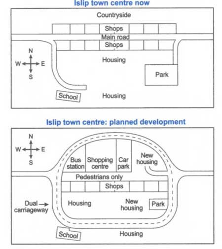
The maps illustrate the current and predicted future Islip town centre.
Overall, it is clear from the maps that some pedestrianisation is planned for shopping and housing area, while a new road for vehicles is planned .
Focusing on the current map, the town center is developed around a main road, which stretches from the west to the east. There are many shops to the north and to the south of the road. Whilst it of the countryside in the north, a big area is occupied by housing in the south. This area is limited by a park in the east and a school in the south-west. Both of these structures are connected to the main road by side roads.
Moving on to the predictions, a circular road that goes around the city center attracts attention. This road expected to be built is a dual carriageway. The middle part of the main road is projected to be pedestrianised. Although the southern part of Islip is not to see big changes other than some new housing and a in the size of the park, there are many changes planned for the northern part. Shops in this part will be demolished and a shopping centre and a housing area will be introduced. A bus station and a parking area are also planned to be built to the west and the east of the shopping centre, respectively.
This is a great report. All aspects were covered and a fully developed response was provided. Some mistakes are still present and require more attention. The vocabulary could have been enhanced further and this report would benefit from more frequent use of complex structures. Overall, seems worthy of Band 8.
Click here to see more IELTS reports of band 8
Help me evaluate this essay please I got band 1 in testbig site
The maps illustrate the current and some proposed changes of Islip town.
Overall, new spots are anticipated to replace shops and countryside at north side and some minor altercation at south.
Currently, there is the main road which stretches from west to east. Also, row of shops are can be seen at north and south of the main road. Although the north of the main road is mainly countryside, a big area at the south part is covered with accommodations. Moreover, we can see that school is at the south-west of housing and park at east side which links path to both places from the main road.
Moving on to the projection of Islip town, the middle of road is expected to be removed within certain length. Instead, pathways will be created for pedestrians while bus station, shopping centre, car park, and new housing would also take over the countryside and shops respectively from west to east. Taking into consideration, shops that are affected after the creation of pedestrian road are relocated after demolishing housing in the middle. Not to mention the park will be narrowed in order to build new housing property. In fact, circular dual carriageways is formed along the new facilities connecting the current road at school and park.
Hi Lee, you can submit your essay to our teachers for checking, all you need is to purchase a writing correction package here.
Brilliant thanks for the giving answer
Nice
I’m glad it helps!
Is there any charges to post task solutions
It doesn’t cost anything to put your own essay or report in a comment. If you would like to get some feedback on your writing, please visit this page, choose a package and proceed to pay and submit your work.
Yeah it’s more benefited for us
And thank you so much
I want to be confident.my writing is not good